Saturday, May 27, 2006
Mount Lemmon
Sometimes there’s a good reason for the road less traveled being less traveled. We decided to take the back way up to the top of Mt. Lemmon, 9157 feet. The pavement ended almost immediately, and one of the few signs we saw was at the beginning: Mt. Lemmon 50 miles. The unpaved road quickly deteriorated into more of a wide path of dirt, rocks and sand. As we got higher, the road narrowed even more, and each curve was tighter than the last. Need I mention the truck is an extended bed with a poor turning radius? About three hours later we had passed a dozen cows, four horses and two guys on ATVs. The desert landscape slowly transformed into forest, as aspens and pine replaced cacti. If the signs about recent fire activity and flash flood hazards weren’t unnerving enough, we had also reached bear country. The last 14 miles took just over an hour. Just before we finally saw a few campsites and reached pavement at last, we caught up to the ATV-ers pulled over to the side surveying the landscape. “So, you made it!?” one of them called out as we passed, as if they had placed bets on whether we were ever to be heard from again. Once on the peak, the only thing keeping us from descending was that we couldn’t get the truck back out of 4-wheel drive (quickly solved by consulting the manual) and that the speedometer had stopped working (that inexplicably fixed itself). The front of Mt. Lemmon was beautiful! It looked more like Colorado than Arizona. We must have stopped at a dozen pull-offs before the 60 degree temperature we enjoyed on the mountaintop crept back up to 90 as the sun went down.
For more mountain scenes click here- http://s78.photobucket.com/albums/j97/d3loeber/Tucson/Mount%20Lemmon/
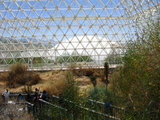
Biosphere 2
Biosphere 2 is a project initiated by a Mr. Bass. The part of it most people have heard of it “The Man Project,” in which four men and four women successfully lived within this closed environment where everything was used and recycled. They grew crops, had animals (the pigs were soon slaughtered, but the goats and chickens were used for their products), and maintained the machinery that controlled their air, humidity and pressure. After two years inside, the project was deemed a success. Later, Columbia University entered into an agreement to use the facility for research, which they did for a number of years. We were told the University reneged on the agreement, leaving Biosphere 2’s future up in the air. They have not been able to find anyone else who can afford to take Columbia’s place so far.
Biosphere 2 contains a rainforest, desert, savanna, marsh and ocean (a million gallons of seawater complete with a living coral reef). Each is a biome, a self-sustaining community of living organisms. Underneath, a 500-ton stainless steel liner separates it from the Earth. The white domes through the glass in the photo above are air-volume control devices containing a giant membrane to accommodate changing air pressure/temperature.
For a better "Lung" photo and others click here- http://s78.photobucket.com/albums/j97/d3loeber/Tucson/Biosphere%202/
Friday, May 26, 2006
Pima Air and Space Museum
Some people had mentioned the airplane graveyard on the east side of Tucson. The dry, sunny weather makes this a good spot for long and short-term storage of military and commercial planes. There are thousands and thousands on both sides of the highway, though less, we were told, than before 9/11. The world’s largest privately funded aerospace museum, The Pima Air and Space Museum is in the middle of this area. There are five hangars to explore with exhibits from the Wright Brothers’ first flight to modern experimental aircraft. Outside are acres and acres of helicopters, attack aircraft, transport units, reconnaissance planes, rescue vehicles, commercial, NASA and military planes. Highlights were a walk through the Kennedy/Johnson Airforce 1, and SR-71 Blackbird, which holds the record of the world’s fastest plane (that they want known publicly at least). At around 2200 mph, it can go coast to coast in just over an hour.
For more aero photos click here- *FYI there are 2 pages
http://s78.photobucket.com/albums/j97/d3loeber/Tucson/Pima%20Air%20and%20Space%20Museum/
Thursday, May 25, 2006
Arizona-Sonora Desert Museum
Tucson has more museums than you might imagine. One of the more interesting outdoor examples we found was the Arizona Sonora Desert Museum. It’s kind of a cross between botanical garden, modern zoo and hiking trail. All of the habitats, especially on the outer, unpaved trail, seemed very natural and open. Some were designed with invisi-wire that made it feel like you were walking right next to the animals. We came around one corner and a coyote was lying under a tree yawning right in front of us. Wolves jogged around in circles waiting for lunch. Javelinas nosed around the shrubbery and gathered under a stone bridge where there was shade and a bit of water. There were many other examples of indigenous plants and animals, and docents were posted here and there providing more specific information and giving presentations. We got some interesting facts about the agave cactus this way. Later, we sat in on a presentation by some herpetologists about venomous snakes and lizards of the desert. The Gila monster looked pretty in salmon and black until she pooped on the demonstration table, and the rattlesnakes didn’t stop rattling the whole time.
For some widlife photos click here- http://s78.photobucket.com/albums/j97/d3loeber/Tucson/Arizona%20Sonora%20Wildlife%20Museum/
Saturday, May 20, 2006
Paseo del Volcan
A few miles west, we drove along the Paseo del Volcan to hike among what’s left of Albuquerque’s volcanoes. Lava once flowed from a 5-mile fissure in the earth’s surface, creating the striking geological features we see today. There are five cones.
More pics http://s78.photobucket.com/albums/j97/d3loeber/Albuquerque/Volcanoes/
Petroglyph National Monument
New Mexico is home to one of the largest collections of petroglyphs in North America. We chose a hike through Rinconada Canyon, about 2.5 miles through the sand dunes, with volcanic rock rising high on either side. The canyon is part of the Santa Fe Formation, though to be up to 25,000 feet thick in some parts. Pueblo and other tribes lived in adobe villages along the Rio Grande and used this area for hunting, gathering, some farming, and cultural and religious activities. The petroglyphs are mostly human-like and animal figures, spirals and geometric designs left by the Pueblo Indians, along with some crosses and animal brand markings left by Spanish explorers and others who settled here later. There is much less graffiti here than in El Paso, but a number of the drawings have been damaged by bullet holes. We even found some shell casings on top of a volcanic hill nearby.
Mas fotos http://s78.photobucket.com/albums/j97/d3loeber/Albuquerque/Petroglyph%20National%20Monument/
Monday, May 15, 2006
Mission Trail
After our day at Hueco Tanks we decided to hit the mission trail. The oldest active missions in the US are in El Paso: Ysleta, Socorro and San Elizario. The three are Spanish built churches established in the last 1600's.
For more shots click here http://s78.photobucket.com/albums/j97/d3loeber/El%20Paso/Missions/
Hueco Tanks
The Hueco Tanks State Historical Site is about 30 miles northeast of El Paso. We got a preview of the general area when we arranged to go to Casey’s (a nice fellow who races his dragster at the El Paso Speedway, and also happens to be the local distributor of Sunoco race fuel). Casey and his family (see photo) got a big kick out of filling our car from his private stash. He didn’t even want to charge!
Hueco Tanks refer to the hollows in the rocks that fill with water when it rains and historically has provided a source of water for whoever inhabits this area at the moment. Archeologists believe that ancient peoples visited here as long ago as 10,000 years. Signs of the Paleo Indians such as tools and arrowheads have been found here. Around 600 AD people began to practice agriculture, and live in small settlements. One group, who probably lived here around 1150, the Jornada Mogollon, left most of the petroglyphs. The over 200 painted masks are part of their art. Later, the Spaniards arrived in the El Paso area, and they along with members of the Apache, Kiowa and Tigua tribes left their marks here as well. In the mid 1800s there was a stop here on the Butterfield Overland Mail Route. People stopped to get food and change out their mules. These days, people visit the area for rest, relaxation and reflection. Unfortunately, many of the petroglyphs have been damaged by graffiti. To try to protect things as much as possible, the park limits the number of visitors. Reservations are required on weekends, and guests must watch an orientation video on the importance of preservation. Enjoy more pics of the beautiful scenery, animals and plants we saw.
For more photos click here http://s78.photobucket.com/albums/j97/d3loeber/El%20Paso/Hueco%20Tanks/
Sunday, May 14, 2006
Texas Mountains???
El Paso, TX desert blooms. Taken in the Franklin Mountains state park. We went for a long hike in the afternoon. We found a few shallow caves which were very handy for taking a break out of the sun. When we got back down to the truck the exterior temp was reading 99 degrees.
Below is a link to our other photos from the day. We suggest using the slideshow feature on the left of the page.
http://s78.photobucket.com/albums/j97/d3loeber/El%20Paso/
Subscribe to:
Posts (Atom)